|
Charizard2993 | | 09/05/12 01:02 am - Last edited 01/16/13 10:11 pm by Charizard2993 | Filter |
|

Graduate

Awards:
 
Group: Member
Posts: 172
| We have pages for Fakemon, Badge designs, and sprites but we don't have any for region maps.
Here are my region maps made so far...
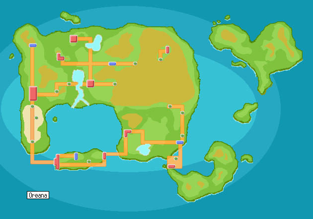
Thr Oreana Region.
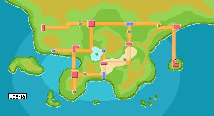
 The Cearia region
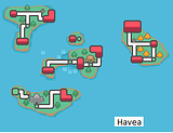
 The Havea Region
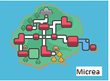
 the Micrea region
 More to come!
  Feel free to subbmit your own ideas.
------------
|
|
|
|
Coronation | |

Guild Member
Awards:
  
Group: Member
Posts: 833
| Your region map is nice I see you went with a D/P style  Did you use a tutorial to make it or did you just go from scratch? I'm curious about the large mountainous area towards the top-right of the mainland - if the area in the middle is a camp or settlement, why do the lines cut off there? Is it because there's no defined path?
And speaking of maps, maybe I should start working on Part 2/3 of my region as well... Did you use a tutorial to make it or did you just go from scratch? I'm curious about the large mountainous area towards the top-right of the mainland - if the area in the middle is a camp or settlement, why do the lines cut off there? Is it because there's no defined path?
And speaking of maps, maybe I should start working on Part 2/3 of my region as well...
------------
|
|
|
|
Charizard2993 | |
Group: Member
| The light brown patches are mountain areas, the largest mountain on the main land is Mt. Erebus (you can read more about it in pokemon project 101). But the inside of the mountain is like a maze that you can exit out of at any of the green dots closest to the Mt. The city on the mountain is a small valley hidden in the mountain. |
|
|
|
Nick | |

Student

Awards:
 
Group: Member
Posts: 21
| Wow, these are super cool dude! Maybe I'll make me a region eventually. xP
------------
|
|
|
 awesome region maps


 Feel free to subbmit your own ideas.


 Did you use a tutorial to make it or did you just go from scratch? I'm curious about the large mountainous area towards the top-right of the mainland - if the area in the middle is a camp or settlement, why do the lines cut off there? Is it because there's no defined path?
And speaking of maps, maybe I should start working on Part 2/3 of my region as well...
Did you use a tutorial to make it or did you just go from scratch? I'm curious about the large mountainous area towards the top-right of the mainland - if the area in the middle is a camp or settlement, why do the lines cut off there? Is it because there's no defined path?
And speaking of maps, maybe I should start working on Part 2/3 of my region as well...